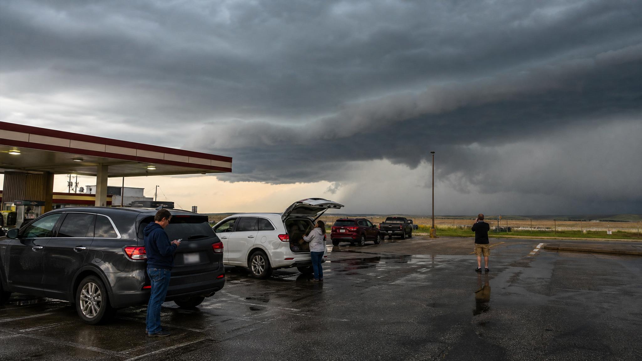
Friday's severe-weather risk has two main parts: a hail and damaging-wind setup in the southern High Plains, and a heavy-rain pattern that could trigger scattered flash flooding from the Ohio Valley to the western Gulf Coast.
The NOAA Storm Prediction Center's Day 1 Convective Outlook issued at 0600 UTC Friday, May 22, 2026, places a Slight Risk of severe thunderstorms across parts of the southern High Plains. SPC says thunderstorms with large hail and severe wind gusts will be possible from late afternoon into the evening, with hailstones greater than 2 inches possible if dominant supercells form.
The Weather Prediction Center says a slow-moving frontal system will keep much of the eastern half of the country unsettled heading into Memorial Day weekend. WPC's short-range discussion warns of scattered flash-flood potential from the Ohio Valley to the western Gulf Coast, with cool, wet, unsettled conditions likely to affect parts of the Mid-Atlantic and Northeast.
Where severe storms are most likely Friday
The clearest organized severe-weather threat is in the southern High Plains. SPC says thunderstorms are expected to develop late Friday afternoon along a moisture gradient from the western Texas Panhandle southward into west Texas, then move east across the region through the late afternoon and evening.
The strongest instability is forecast over the low Rolling Plains of northwest Texas. SPC says the environment can support supercells with large hail and severe wind gusts. If a storm becomes dominant, hail larger than 2 inches in diameter is possible.
The greatest severe threat is expected in the evening as a broken line of storms moves into stronger instability from the eastern Texas Panhandle southward into northwest Texas.
What a Slight Risk means
SPC's severe-weather outlook scale runs from Marginal Risk to High Risk. A Slight Risk is level 2 out of 5. It does not mean the weather is harmless. It means organized severe thunderstorms are expected, but coverage or intensity is usually lower than in Enhanced, Moderate, or High Risk setups.
For readers, the practical meaning is simple: most places in the risk area may not see the worst storm, but any storm that becomes severe can still produce damaging wind, large hail, or dangerous conditions. Check updates before the afternoon and evening storm window, and do basic preparation before warnings are issued.
Why hail is the headline in the southern High Plains
Large hail is one of the most expensive and disruptive thunderstorm hazards because it can damage cars, roofs, siding, crops, solar panels, skylights, and outdoor equipment.
The National Weather Service defines a severe thunderstorm as one capable of producing hail at least 1 inch in diameter or wind gusts over 58 mph. SPC's May 22 outlook goes beyond that threshold by noting that hailstones greater than 2 inches could occur with stronger supercells in northwest Texas and nearby areas.
If you live in or near the southern High Plains risk area, move vehicles under cover before storms form if you can do so safely. Bring pets inside, close garage doors, secure outdoor items, and avoid being outside when storms approach.
Other regions to watch
The southern High Plains has the clearest hail and wind setup, but it is not the only area in the outlook.
SPC says isolated severe gusts and hail may occur in parts of the mid-Missouri Valley. In eastern Nebraska, storms may develop Friday afternoon along and near a low-level moisture axis, with low-topped supercells capable of isolated severe wind gusts and hail.
From the central Gulf Coast states into the Tennessee and southern Ohio valleys, SPC says scattered thunderstorms will develop in a moist and unstable air mass. The main severe-weather concern there is isolated damaging wind, with a marginal tornado threat also possible.
That tornado language should not be overstated. Tornadoes are not the headline hazard in the Friday morning outlook. It does mean readers in that region should keep alerts on and know where to shelter if a warning is issued.
Flash flooding is the other major concern
WPC's Friday morning forecast highlights scattered flash-flood potential from the Ohio Valley to the western Gulf Coast states.
The setup involves a slow-moving, wavy frontal system separating warm, humid air to the south from cooler, less humid air to the north. Disturbances moving along that boundary can produce multiple rounds of showers and thunderstorms from the southern Plains and Deep South into the Ohio Valley.
WPC says many storms will contain heavy rainfall. The concern is especially notable across parts of the Ohio Valley and southern Appalachians Friday afternoon and evening, where increasing moisture and instability could allow clusters of storms to produce locally intense rainfall over increasingly saturated soils.
WPC's Day 1 Excessive Rainfall Outlook issued at 0804Z lists a Slight Risk, level 2 out of 4, for parts of the flash-flood zone. The outlook display lists 12,897,687 people in the Slight Risk and 50,437,598 people in a broader Marginal Risk.
What watches and discussions show now
At 10:48 UTC Friday, SPC's current watches page said no convective watches were valid. Its current mesoscale discussions page listed Mesoscale Discussion 0823, issued at 1006 UTC and valid until 1200 UTC, concerning severe potential with a watch unlikely.
That status can change quickly later in the day. Watches are planning alerts for broader areas. Warnings are immediate action alerts for specific locations. For the southern High Plains, the main storm window is later Friday, so readers should check SPC, local NWS offices, and phone alerts again before afternoon and evening plans.
How this affects Memorial Day weekend travel
The weather pattern is arriving just as many people are starting Memorial Day weekend trips.
WPC says cool, wet, and unsettled weather will likely put a damper on some holiday weekend activities, especially on the cooler side of the front in the Mid-Atlantic and Northeast as waves of showers move through. Highs in the 50s and 60s in parts of that region will contrast with the earlier heat.
For travelers, the biggest issues are not just rain totals. Repeated showers and storms can slow highway travel, cause ponding on roads, delay outdoor events, and disrupt airport operations if thunderstorms move near major hubs.
- Check your local NWS forecast at weather.gov.
- Review SPC watches and mesoscale discussions before leaving.
- Check WPC excessive rainfall outlooks for flood risk along your route.
- Look at radar and state road alerts close to departure time.
- Check airport and airline status pages if you are flying.
What to do if roads flood
Flooding is a travel hazard because it can be hard to judge depth, road damage, and current strength in the moment.
The National Weather Service emphasizes that drivers need to know what to do when they hit a flooded road. The safest rule is still the simplest one: if water covers the road, turn around and choose another route. Do not assume familiar roads are safe, and do not drive around barricades.
For Friday and Saturday travel, check state transportation alerts, local NWS warnings, and local emergency management updates before leaving. If your route crosses low-water crossings, small creeks, underpasses, or urban drainage trouble spots, build in extra time or choose a safer route.
Watch vs warning: what changes your action
A severe thunderstorm watch means conditions are favorable for severe storms in and near the watch area. Use that time to charge devices, secure outdoor items, bring pets inside, and be ready to move to shelter.
A severe thunderstorm warning means severe weather is happening or imminent. Move inside a sturdy building, stay away from windows, and avoid driving into the storm.
A flash flood warning means flooding is happening or expected soon. Move away from flood-prone areas and never drive through water-covered roads.
A tornado warning means a tornado has been indicated by radar or observed. Move to a basement or an interior room on the lowest level of a sturdy building, away from windows.
Quick prep checklist for Friday
- Charge phones, power banks, laptops, flashlights, weather radios, and medical devices that rely on electricity.
- Bring in or tie down patio furniture, umbrellas, trash cans, sports gear, tools, flags, and lightweight decorations.
- If you are in the southern High Plains risk area, move vehicles into a garage, carport, covered lot, or parking structure before storms develop.
- Check alerts for your exact location, not just broad national outlooks.
- Plan around travel timing if your route crosses the Texas Panhandle, northwest Texas, the Ohio Valley, the Tennessee Valley, the central Gulf Coast, or flood-prone parts of the East.
- Pick an interior room on the lowest level of a sturdy building before warnings arrive.
FAQ
Where is the highest severe-weather risk on May 22?
SPC places the main Slight Risk across parts of the southern High Plains, with the greatest concern focused from the eastern Texas Panhandle southward into northwest Texas during the late afternoon and evening.
What are the main threats?
The southern High Plains risk is mainly large hail and severe wind gusts. SPC says hailstones greater than 2 inches are possible with dominant supercells. Other regions may see isolated severe wind, hail, and a marginal tornado threat.
Is there a tornado risk today?
SPC mentions a marginal tornado threat from the central Gulf Coast states into the Tennessee and southern Ohio valleys. Tornadoes are not the headline hazard in the Friday morning outlook, but any tornado warning should be treated as urgent.
Where is flash flooding possible?
WPC highlights scattered flash-flood potential from the Ohio Valley to the western Gulf Coast states over the next couple of days, with heavy rainfall possible in repeated rounds of showers and storms.
Are watches already issued?
SPC's current watches page said no convective watches were valid at 10:48 UTC Friday, May 22. The mesoscale discussions page listed Mesoscale Discussion 0823 for severe potential with a watch unlikely, valid until 1200 UTC.
Should Memorial Day travelers change plans?
Not everyone needs to cancel plans, but travelers should build in flexibility. Check local alerts, road conditions, airport status, and radar before leaving, especially if traveling through the southern High Plains, Ohio Valley, Tennessee Valley, Gulf Coast states, Mid-Atlantic, or Northeast.
Bottom line
Severe weather on May 22 is not a single-region story. The southern High Plains has the clearest hail and wind risk, while the Ohio Valley to western Gulf Coast corridor has a meaningful flash-flood concern. Much of the East is also heading into a wet, unsettled Memorial Day weekend.
The best move is practical preparation: protect vehicles from hail where possible, secure outdoor items, charge devices, avoid flooded roads, and follow local National Weather Service warnings as Friday's storms develop.
Sources
- NOAA Storm Prediction Center Day 1 Convective Outlook. Used for the May 22 Slight Risk, hazard areas, timing, hail, wind, and marginal tornado language.
- NOAA Storm Prediction Center Current Convective Watches. Checked for valid watches at publication time.
- NOAA Storm Prediction Center Mesoscale Discussions. Used for current mesoscale discussion status at publication time.
- NWS Weather Prediction Center Short Range Forecast Discussion. Used for flash-flood, Memorial Day weekend, and eastern U.S. weather context.
- NWS Weather Prediction Center Day 1 Excessive Rainfall Outlook. Used for Day 1 risk levels and affected population counts.
- National Weather Service severe thunderstorm safety guidance. Used for severe-thunderstorm definitions and safety context.
- National Weather Service flood safety guidance. Used for flood-safety framing.