Severe weather on Tuesday, June 9, is a serious afternoon and nighttime concern for parts of the Plains. The NOAA Storm Prediction Center's Day 1 Convective Outlook, updated at 0554 UTC Tuesday, places an Enhanced Risk across parts of the central and northern Plains and says numerous severe thunderstorms are expected from this afternoon into tonight.
The strongest hazards in the outlook are damaging wind gusts of 60 to 80 mph, locally higher gusts, large to very large hail, and tornadoes. SPC also says a couple of strong tornadoes may occur.
This article was refreshed before publication against SPC outlooks, SPC current watches, SPC mesoscale discussions, WPC's short-range forecast discussion, WPC excessive-rainfall guidance, and National Weather Service safety pages. The next SPC Day 1 update was scheduled for 1300 UTC, but it had not posted at this final pre-publication check, so local readers should refresh official alerts before making plans.
Severe weather June 9, 2026: areas to watch
SPC's more focused severe-weather corridor extends from central and northern Nebraska into central and eastern South Dakota, southeastern North Dakota, and western Minnesota. The broader risk area also reaches parts of the central Plains, northern Plains, Upper Midwest, and adjacent areas.
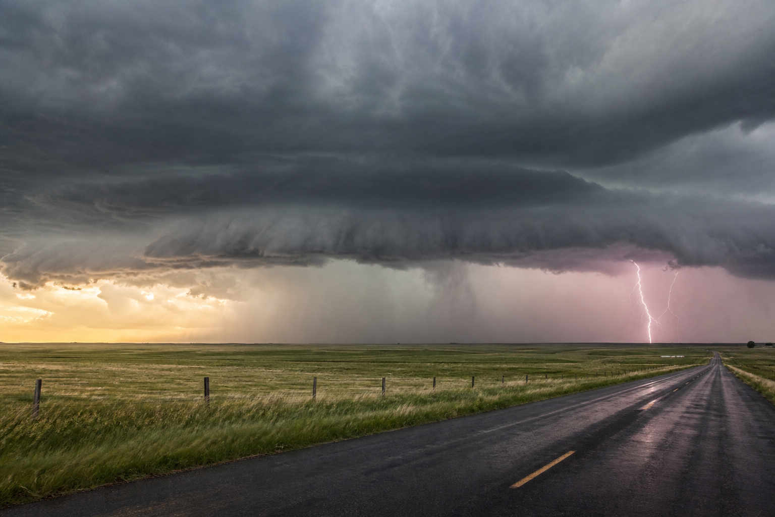
The setup depends on storms developing near a surface low and front in the northern Plains, then organizing as they move through a strongly unstable air mass. SPC describes a favorable environment for supercells early, with the potential for storms to grow upscale into one or more organized lines later.
That matters because the first storms may be capable of very large hail and tornadoes, while a later line could raise the threat for more widespread damaging wind.
Why an Enhanced Risk deserves attention
An Enhanced Risk is not the highest category SPC uses, but it does signal a more concentrated or more intense severe-thunderstorm threat than a Marginal or Slight Risk. It means residents in the outlined area should treat the forecast as actionable, not background noise.
For June 9, SPC's outlook is especially notable because it includes multiple serious hazards at once: possible strong tornadoes, very large hail, and damaging wind gusts that could reach 60 to 80 mph or higher in localized corridors.
Practical impacts can include downed trees and power lines, vehicle and roof damage, broken windows, road hazards, and dangerous conditions for anyone caught outside, in a vehicle, or in a mobile or manufactured home during a warning.
When storms are most likely
The highest-risk window is expected to develop this afternoon and continue into tonight. Exact timing will depend on where storms first form, how quickly the cap weakens, and whether individual storms remain discrete or merge into a larger line.
Morning and early midday quiet should not be treated as an all-clear. On Plains severe-weather days, the atmosphere can look calm for hours before storms rapidly intensify late in the day.
If you are in or near the risk area, check your local National Weather Service office before afternoon errands, evening commute plans, outdoor work, youth sports, or long drives.
No watch this morning does not mean no risk later
At the final pre-publication check, SPC's current watches page had been updated at 1007 UTC and listed no valid convective watches. SPC's mesoscale discussions page was also updated at 1007 UTC and listed no mesoscale discussions currently in effect.
That status is only a snapshot. Watches and mesoscale discussions are shorter-fuse products, often issued closer to storm development when forecasters have better confidence in where storms will initiate and how they will organize.
Before storms approach, make sure Wireless Emergency Alerts are enabled, have more than one way to receive warnings, and know where you would go for a tornado warning or a destructive severe-thunderstorm warning.
Heavy rain and flooding remain part of the broader pattern
WPC's short-range discussion, issued at 0742 UTC Tuesday, highlights severe thunderstorm chances over the Northern and Central Plains on Tuesday and into the upper Mississippi Valley on Wednesday. It also notes heavy-rain and flash-flood concerns from the Midwest to the central Gulf Coast.
Flooding can happen away from the worst hail or tornado reports. Slow-moving storms, repeated rounds of rain, saturated ground, poor drainage, and low-water crossings can all create dangerous conditions quickly.
If a road is covered by water, turn around. It is not possible to judge road depth, road damage, or current strength safely from a vehicle.
What to do before storms arrive
- Search your city or ZIP code at weather.gov and read the local forecast discussion or hazardous-weather outlook if available.
- Charge your phone and keep Wireless Emergency Alerts turned on.
- Move vehicles under sturdy cover if it is safe to do so before storms develop.
- Secure patio furniture, trash bins, sports equipment, grills, and other loose outdoor items.
- Know the difference between a watch and a warning: a watch means conditions are favorable, while a warning means dangerous weather is occurring or imminent.
- For a tornado warning, go to a basement or an interior room on the lowest floor of a sturdy building.
- For a severe thunderstorm warning with destructive winds or very large hail, move inside and stay away from windows.
- For a flash flood warning, avoid flooded roads and move to higher ground if instructed by local officials.
What to check through the day
The most important updates today will be SPC's next Day 1 outlook, any issued severe thunderstorm or tornado watches, mesoscale discussions, local NWS warnings, and radar trends. A local alert can be more important than the national map once storms begin.
People with evening travel across Nebraska, South Dakota, North Dakota, western Minnesota, or nearby Plains states should build in flexibility. Delaying a drive by even 30 to 60 minutes can matter if a warning polygon is crossing the route.
FAQ
Where is the highest severe-weather risk on June 9?
SPC's Enhanced Risk focuses on parts of the central and northern Plains, especially from central and northern Nebraska into central and eastern South Dakota, southeastern North Dakota, and western Minnesota.
What are the main hazards today?
SPC says damaging wind gusts of 60 to 80 mph, locally higher gusts, large to very large hail, and tornadoes are possible. A couple of strong tornadoes may occur.
Are there severe thunderstorm or tornado watches right now?
At the final pre-publication check, SPC listed no valid convective watches at 1007 UTC on June 9. Watches can be issued later, so refresh SPC and local NWS alerts before afternoon and evening plans.
What does an Enhanced Risk mean?
An Enhanced Risk means SPC sees a more concentrated or more intense severe-thunderstorm threat than a lower-end risk category. It is a signal to prepare before storms arrive and to pay close attention to warnings.
Can flooding happen even if my area is not in the highest tornado or hail risk?
Yes. Flash flooding depends on rainfall rate, storm movement, drainage, terrain, and soil conditions. Heavy rain can become dangerous even outside the most intense wind, hail, or tornado corridor.
Bottom line
Tuesday's severe-weather setup is not just a map color. It is a late-day and nighttime risk with enough instability and wind shear to support tornadoes, very large hail, and damaging wind. If you are in or near the central or northern Plains risk area, use the morning and early afternoon to prepare, then keep official alerts close as storms develop.
Sources
- NOAA Storm Prediction Center Day 1 Convective Outlook. Used for the June 9 Enhanced Risk, hazard language, affected areas, and outlook-update timing.
- NOAA Storm Prediction Center Current Convective Watches. Checked for valid watch status at publication time.
- NOAA Storm Prediction Center Mesoscale Discussions. Checked for current mesoscale discussion status at publication time.
- NWS Weather Prediction Center Short Range Forecast Discussion. Used for broader severe-weather, heavy-rain, and flash-flood context.
- NWS Weather Prediction Center Excessive Rainfall Outlook. Used for excessive-rainfall risk context.
- National Weather Service severe thunderstorm safety guidance. Used for severe-thunderstorm safety context.
- National Weather Service tornado alerts guidance. Used for watch and warning definitions.
- National Weather Service flood safety guidance. Used for flood-safety framing.