Post-Tropical Cyclone Arthur flooding remains the practical story even after the storm's label changed.
At 2 a.m. EDT Friday, June 19, the National Hurricane Center said showers and thunderstorms tied to a trough of low pressure, the remnants of Arthur, were over the southeastern United States. NHC said the system was expected to emerge offshore the East Coast by Friday afternoon, then move northeastward across the western Atlantic. The formation chance was low, at 10% through 48 hours and seven days.
That low formation chance should not be read as an all-clear. NHC also said heavy rainfall with the potential for widespread and life-threatening flash flooding is likely across portions of the Southeast during the next day or two, regardless of development.
For readers in Louisiana, Mississippi, Alabama, the Florida Panhandle, Georgia, the Carolinas, and nearby inland areas, the safest way to think about Arthur now is simple: the name is less important than the rain bands, local warnings, flooded roads, river forecasts, rip currents, and any fast-moving storms still crossing the region.
This article is based on official source checks completed Friday morning, June 19. Conditions can change quickly. Use your local National Weather Service office, emergency-management alerts, state transportation updates, river forecasts, and local media for decisions in your exact area.
What changed by Friday morning
Arthur's threat has shifted from a named-storm tracking question to a local-impact question.
Earlier this week, the key public question was whether a Gulf disturbance would become a tropical storm and where the heaviest rain would form. By Friday morning, NHC was describing the system as Arthur's remnants over the Southeast, with only a low chance of renewed subtropical or tropical development once it moved offshore.
The hazards did not end with that shift. The Weather Prediction Center's Day 1 Excessive Rainfall Outlook, valid from 12 UTC Friday to 12 UTC Saturday, placed a Moderate Risk of excessive rainfall over parts of the central Gulf Coast. WPC said the main reason for maintaining that risk was that storms were likely to overlap an area that recently received widespread 4 to 8 inches of rain, with local totals over 12 inches, leaving soils extremely saturated.
That is why "low formation chance" does not mean "low flood risk." Flooding can continue when a tropical system weakens, loses structure, or moves away, especially if drainage systems, creeks, rivers, and soils are already overloaded.
Where the flood risk remains most serious
The Friday morning flood concern is focused on the central Gulf Coast and nearby Southeast, with additional scattered flash-flood concerns extending into eastern Texas and parts of the lower Mississippi Valley.
WPC highlighted southern Alabama and the Florida Panhandle in its Day 1 discussion, noting high probabilities for intense short-duration rainfall early in the period before the signal becomes more scattered. It also kept a broader Slight Risk from eastern Texas into the central Gulf Coast because the environment can still support heavy rainfall rates, even where individual thunderstorms are uncertain.
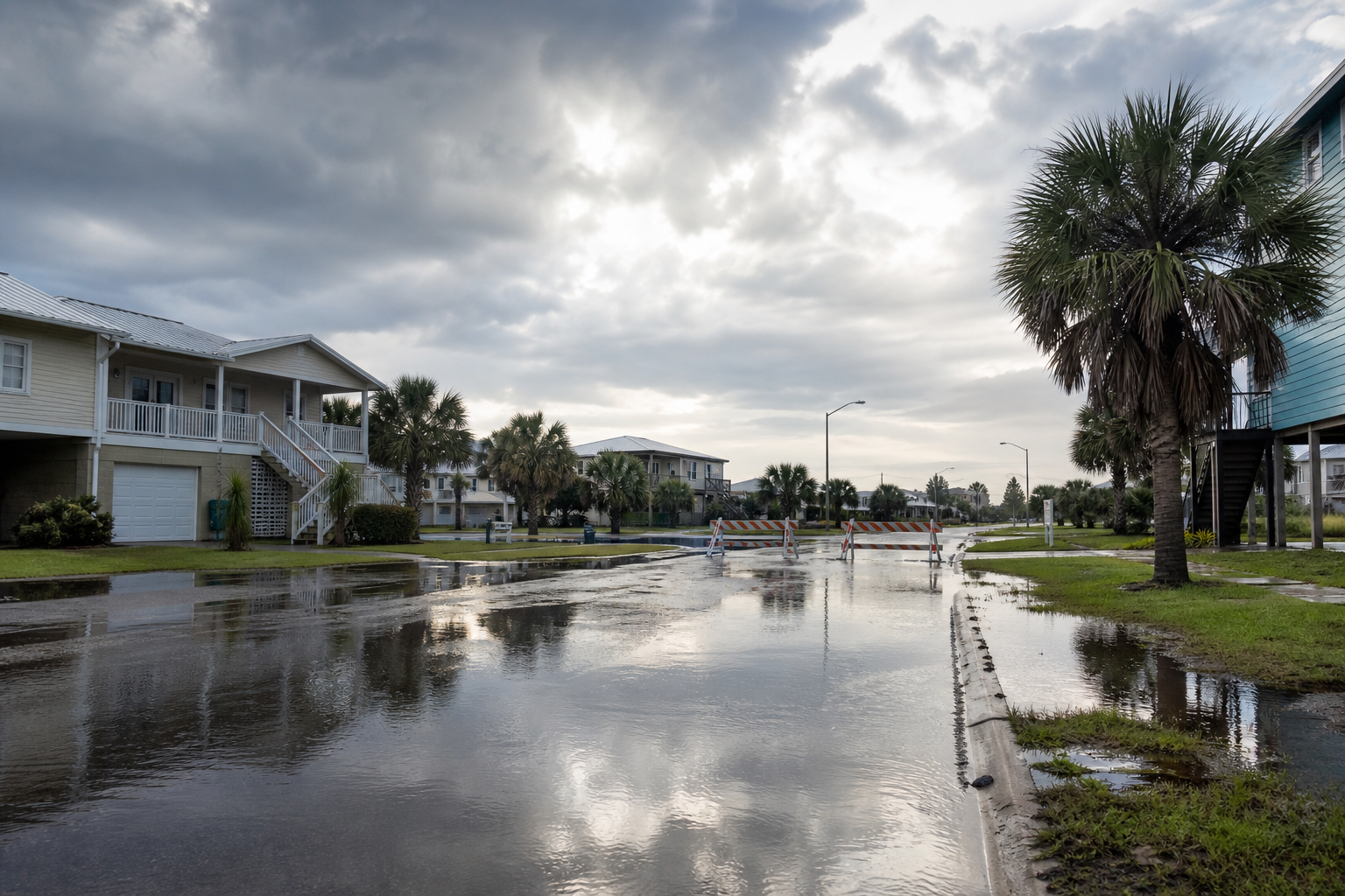
National Weather Service active alerts during the Friday morning publish check showed multiple flood warnings in Alabama counties including Mobile, Baldwin, Escambia, and Covington; flood watches and warnings in parts of Mississippi and Louisiana; flood warnings and rip-current statements in parts of the Florida Panhandle; and flood watches in parts of Georgia.
Those alerts matter more than a national map alone. A reader in a county under a flood warning has a different decision than someone outside the warning area. A commuter crossing low roads has a different risk than someone staying put on higher ground. A coastal visitor facing rip-current statements has a different risk than an inland reader watching creeks and drainage ditches.
Why flooding can continue after Arthur weakens
Flooding after a tropical system is often a lagging hazard.
Rain can keep falling after a storm's name fades from headlines. Rivers can crest after the heaviest rain has moved away. Flooded roads can stay closed into the next day. Soil that already took on several inches of water can turn a new round of storms into runoff much faster than usual.
WPC's Friday discussion points to that overlap problem: storms may move through areas that have already had heavy rain. That increases the chance that rainfall rates which might be manageable on dry ground become dangerous on saturated ground.
The result is a day where the right question is not "Is Arthur still a tropical cyclone?" The better question is "Is my local area under a flood warning, flood watch, river flood product, rip-current statement, severe-thunderstorm warning, or road closure?"
Severe storms are a secondary risk
The Storm Prediction Center's Day 1 outlook issued at 0600 UTC Friday placed a Marginal Risk of severe thunderstorms from Texas to Florida and the eastern Carolinas, and over parts of the central Plains and Upper Mississippi Valley.
For the Arthur-related corridor, SPC said additional strong thunderstorms may produce damaging wind gusts from north Texas and southern Oklahoma through portions of the Gulf Coast states and into the coastal Carolinas. It also noted a low probability of a brief tornado and damaging gusts ahead of a wave moving across the Carolinas before the system moves offshore.
A Marginal Risk is not the same as a high-end outbreak, but it is enough reason to keep alerts on. Heavy rain can reduce visibility, downbursts can knock down limbs or power lines, and brief embedded rotation can be hard to see through rain.
Rip currents are still a coastal hazard
The Florida Panhandle alert check also showed rip-current statements for multiple coastal zones, including parts of Gulf, Walton, Bay, and Franklin counties.
Rip currents can stay dangerous even when the center of a system is no longer nearby and skies start to improve. Beach visitors should check local beach flags, lifeguard guidance, local government updates, and National Weather Service coastal hazard products before entering the water.
If caught in a rip current, do not fight directly against it. Float, call or wave for help, and swim parallel to the shoreline when possible until you are out of the current.
What to check before driving today
The biggest everyday risk with Arthur's remnants is still driving into water.
Before commuting, school pickup, errands, cleanup, or travel through the affected region, check:
- Your local NWS office for flash flood warnings, flood warnings, tornado warnings, severe-thunderstorm warnings, and special weather statements.
- Local emergency-management alerts for evacuation notices, road closures, shelter openings, and rescue requests.
- State and local transportation maps for flooded roads, closed bridges, and washed-out routes.
- River forecast pages if you live near creeks, bayous, streams, or larger rivers.
- Power outage maps if you depend on electric medical equipment, refrigeration, sump pumps, or work-from-home connectivity.
- Airline and airport alerts if you are traveling through Gulf Coast, Southeast, or coastal Carolina airports.
Do not drive around barricades. Do not assume water is shallow because another vehicle made it through. Water can hide washed-out pavement, fast current, debris, or a stalled vehicle.
What "post-tropical" means for readers
Post-tropical does not mean harmless. It means the system no longer has the same tropical cyclone structure.
For a reader trying to make Friday plans, the better checklist is:
- Is my area under a flash flood warning, flood warning, flood watch, tornado warning, severe-thunderstorm warning, or coastal hazard statement?
- Is heavy rain still upstream of me on radar?
- Are rivers, creeks, or drainage channels rising?
- Are local roads closed or covered?
- Are schools, workplaces, airports, beaches, or public transit systems reporting changes?
- Is another round of rain forecast tonight or Saturday?
If the answer to any of those is yes, the storm label should not change your caution level.
FAQ
Is Arthur still a tropical storm?
No. NHC's Friday 2 a.m. EDT outlook described the system as a trough of low pressure, the remnants of Arthur, over the southeastern United States.
Could Arthur redevelop?
NHC gave the remnants a low 10% formation chance through 48 hours and seven days as the system moves offshore and northeastward across the western Atlantic.
Does that low formation chance mean the flood danger is over?
No. NHC said heavy rainfall with the potential for widespread, life-threatening flash flooding is likely across portions of the Southeast during the next day or two, regardless of development.
Where is the heaviest rain risk today?
WPC's Day 1 Excessive Rainfall Outlook includes a Moderate Risk for parts of the central Gulf Coast, with the discussion focused on southern Alabama and the Florida Panhandle where new storms may overlap saturated ground.
Where should I check local alerts?
Start with weather.gov and your local National Weather Service office. Then check city, county, parish, emergency-management, state transportation, river forecast, airport, and beach-flag sources for local conditions.
Sources
- National Hurricane Center Atlantic Tropical Weather Outlook, issued 2 a.m. EDT June 19, 2026.
- WPC Day 1 Excessive Rainfall Outlook, valid 12 UTC June 19 to 12 UTC June 20, 2026.
- WPC Excessive Rainfall Discussion, checked June 19, 2026.
- SPC Day 1 Convective Outlook, issued 0600 UTC June 19, 2026.
- National Weather Service active alerts, checked for AL, MS, FL, LA, GA, and TX on June 19, 2026.
- National Weather Service flood safety guidance.
- NWS Turn Around Don't Drown guidance.
Related reading: Gulf Coast AL90 Flood Threat, Hurricane Season Prep 2026, Severe Weather June 9, 2026, and Blackout Kit Checklist.