The Gulf Coast AL90 flood threat is not just a tropical-weather story. It is a road, drainage, commute, school, work, and overnight-alert story for parts of Texas, Louisiana, and Mississippi.
As of the National Hurricane Center's 2 a.m. EDT Tuesday, June 16, 2026 outlook, AL90 was a trough of low pressure inland near the Texas and Mexico border that could re-emerge over the northwestern Gulf of America today. NHC said conditions could support a short-lived tropical storm later Tuesday or Wednesday, with a medium 60% chance of formation through 48 hours and seven days.
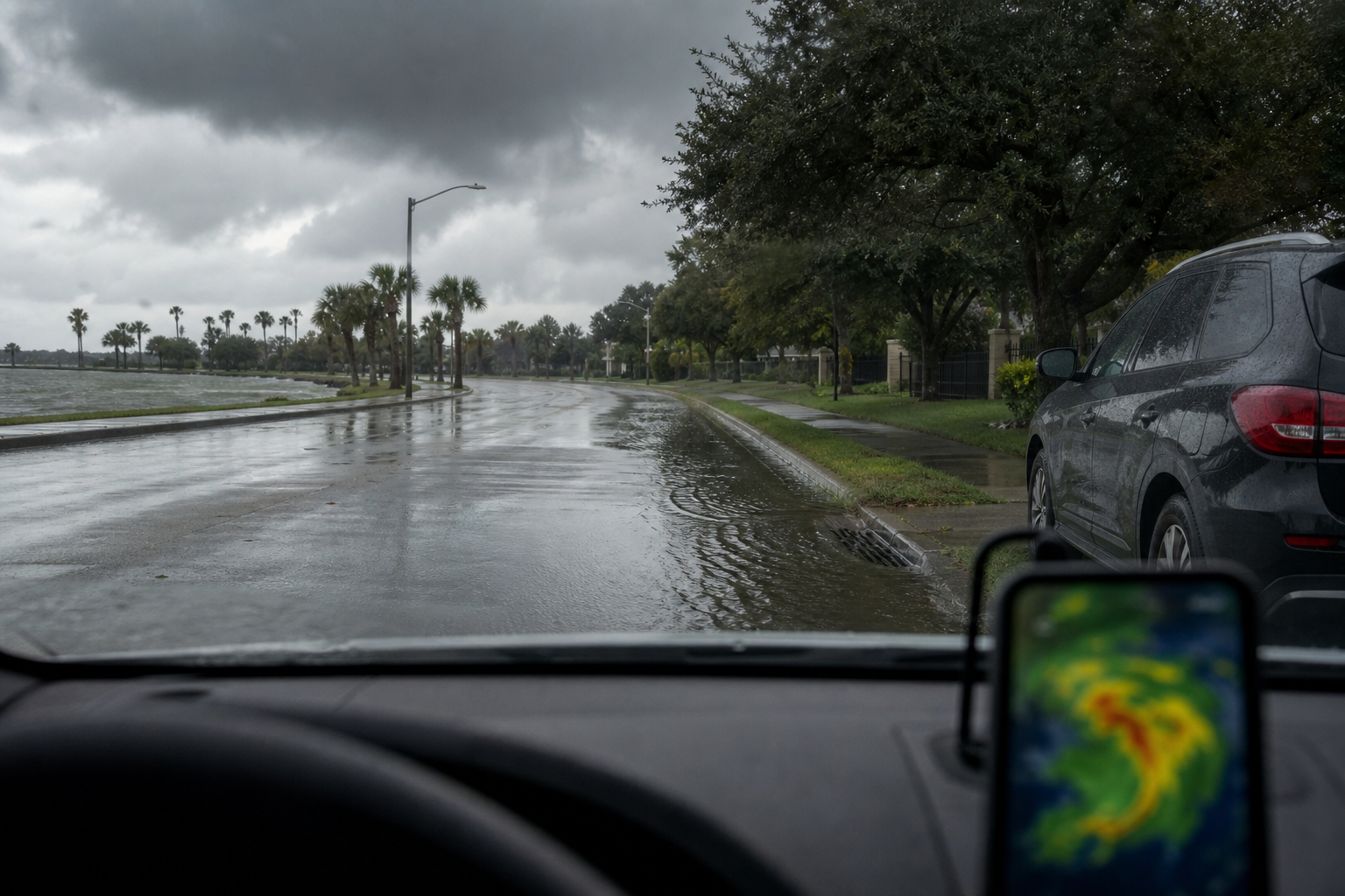
That percentage is important, but it is not the whole risk. NHC also said intense rainfall could produce widespread, life-threatening flash, urban, and river flooding across southern and eastern Texas, portions of Louisiana, and Mississippi regardless of whether AL90 becomes a named storm.
This article is based on official source checks completed Tuesday morning, June 16. Conditions can change quickly. Use local National Weather Service alerts, emergency management notices, road closures, and official forecast updates for decisions in your area.
Why AL90 matters even before a name
AL90 is an invest area, which means forecasters are monitoring a disturbance closely enough to run additional analysis and model guidance. It is not the same thing as a tropical depression, tropical storm, or hurricane.
For readers, the practical point is that Gulf systems can create dangerous rain before they have a clean center or a name. A disorganized trough can still focus tropical moisture into rain bands. Those bands can train over the same roads and neighborhoods. Flooding can develop faster than the headline tropical category changes.
That is why the useful question today is not only "Will AL90 become a tropical storm?" The better question is "Could my city, parish, county, commute, or normal route be under a flood watch, flood advisory, flash flood warning, river flood statement, or coastal flood product?"
What official forecasts said Tuesday morning
The Weather Prediction Center's short-range discussion issued at 4 a.m. EDT Tuesday said a prolonged heavy-rainfall event continues to take shape from South Texas through the lower Mississippi Valley. WPC connected the setup to a low- to mid-level disturbance exiting the Mexican plateau, tropical moisture near the western Gulf and northeastern Mexico, and a cold front becoming nearly stationary just inland from the Gulf Coast.
WPC said storm-total rainfall of 5 to 7 inches, with locally higher amounts, can be expected along the Texas coastline into Louisiana through the next three days. It also said numerous instances of flash flooding can be expected through Thursday morning, some of which could be significant.
The Day 1 excessive-rainfall outlook updated at 0803 UTC Tuesday placed a Moderate Risk for portions of the Texas Gulf Coast through the lower Mississippi Valley. Its discussion highlighted several corridors of concern, including the Texas Gulf Coast, Louisiana, western Mississippi, and areas from roughly Galveston and Trinity Bays east toward Lafayette, Louisiana, depending on how rain bands organize.
SPC's current convective-watch page, checked at 10:53 UTC Tuesday, said no watches were currently valid. That matters for the severe-thunderstorm picture, but flooding can still occur without a severe-thunderstorm watch.
Areas that should pay close attention
The broad national-source watch zone runs from South Texas and the Texas coast into Louisiana and Mississippi. That does not mean every neighborhood sees the same amount of rain. Gulf Coast rain bands are uneven, and the worst impacts often occur where storms repeat over the same location.
Pay close attention if you are in or near:
- Deep South Texas and the middle Texas coast.
- Corpus Christi, Galveston, Houston, and the broader southeast Texas coast.
- Southwest and south-central Louisiana, including the Lake Charles and Lafayette corridors.
- Central Louisiana into western and southern Mississippi, especially where storms train along boundaries.
- Low roads, underpasses, bayous, drainage channels, river-adjacent areas, and neighborhoods with a history of street flooding.
Local forecasts are the deciding layer. Enter your city or ZIP code at weather.gov, then check your local NWS office, county or parish emergency management, city alerts, transportation departments, and flood-warning systems if your area has one.
What a Moderate Risk for excessive rainfall means
WPC excessive-rainfall categories are about the chance that short-duration rainfall exceeds flash-flood guidance at a point. A Moderate Risk is a serious signal that flash flooding is more likely than in lower categories and that some flooding could be significant.
The category does not tell you exactly which street floods. It tells you the environment is supportive enough that people in the outlined region should stop treating the forecast as background noise. That is especially true where soils are already wet, drainage is poor, or storms train over the same area.
Moderate Risk days are not only a rural creek issue. Urban flooding can block frontage roads, feeder roads, underpasses, parking lots, apartment access roads, and normal commute routes. It can also cause problems after dark, when water depth is harder to judge.
Why tropical storm watches or warnings could still matter
NHC said Tropical Storm Watches or Warnings could be required later Tuesday. Those products would focus on tropical-storm conditions, such as sustained winds, but NHC also flagged gusty winds and coastal flooding along portions of the northwestern Gulf Coast.
Do not wait for a tropical watch to take the flood side seriously. A tropical watch would be an additional signal, not the starting point for paying attention. If local officials issue flood watches, flash flood warnings, coastal flood statements, or road closures, those are the action items.
Checks to make before the heaviest rain
Start with alert delivery. Make sure Wireless Emergency Alerts are enabled on your phone. Add your local NWS office, city, county, parish, school district, and emergency management channels where they provide direct updates.
Think through your normal routes before rain is falling. Underpasses, low-water crossings, frontage roads, creek crossings, bayou-adjacent streets, and poorly drained intersections can become unsafe quickly. Decide on an alternate route before the water is already rising.
Move vehicles early if you normally park in a low spot, near a drainage ditch, in an underpass-prone lot, or in an area that has flooded before. Do not move a vehicle once water is already covering the route.
Charge phones, battery packs, flashlights, weather radios, and any devices you use for medical, work, caregiving, or school needs. Keep medications, glasses, documents, pet supplies, and basic supplies where you can reach them quickly.
What to do if a flash flood warning is issued
A flash flood warning means flooding is happening or expected soon in the warned area. At that point, the goal is to reduce exposure quickly.
- Do not drive through water-covered roads.
- Do not walk through flood water.
- Do not go around barricades.
- Keep children and pets away from drainage ditches, creeks, culverts, and fast-moving water.
- If local officials tell your area to move, shelter, or avoid certain roads, follow that local guidance.
The most common mistake is treating water on a road like an ordinary puddle. Flood water can hide road damage, current, debris, or depth changes. It can also rise while you are already committed to a route.
What this forecast does not mean yet
This forecast does not mean every city from Texas to Mississippi will flood. It does not mean AL90 is guaranteed to become a named storm. It does not prove where the heaviest rain band will sit for the entire event.
It does mean official sources are flagging a meaningful, multi-day heavy-rain setup along parts of the western and central Gulf Coast. The safest reader takeaway is to keep checking local alerts, avoid flood-prone roads, and treat overnight warnings seriously.
FAQ
Is AL90 a tropical storm?
No. As of NHC's 2 a.m. EDT Tuesday outlook, AL90 was a trough of low pressure near the Texas and Mexico border. NHC said a short-lived tropical storm could form later Tuesday or Wednesday, but it was not a named storm at that time.
What is the formation chance?
NHC listed a 60% formation chance through 48 hours and a 60% formation chance through seven days in the 2 a.m. EDT Tuesday outlook.
How much rain is possible?
WPC's Tuesday short-range discussion said storm-total rainfall of 5 to 7 inches, with locally higher amounts, can be expected along the Texas coastline into Louisiana through the next three days.
Can flooding happen if AL90 never gets a name?
Yes. NHC specifically warned that intense rainfall and flooding could occur regardless of tropical cyclone formation. Local rainfall rates and repeated bands matter more to flood impacts than the name alone.
Where should I check local alerts?
Start with weather.gov and your local National Weather Service office. Then check city, county, parish, emergency management, state transportation, and local flood-warning systems for alerts and road closures.
Sources
- National Hurricane Center Atlantic Tropical Weather Outlook, checked June 16, 2026.
- Weather Prediction Center Short Range Forecast Discussion, issued 4 a.m. EDT June 16, 2026.
- WPC Day 1 Excessive Rainfall Outlook, updated 0803 UTC June 16, 2026.
- Storm Prediction Center Current Convective Watches, checked June 16, 2026.
- National Weather Service active alerts.
- National Weather Service flood safety guidance.
- NWS Turn Around Don't Drown guidance.
Related reading: Hurricane Season Prep 2026, Severe Weather June 9, 2026, and Blackout Kit Checklist.