Sunday's weather risk is broad, but the practical reader question is simple: where could an ordinary drive, trail stop, beach-town errand, or evening plan turn into a flood, hail, or outage problem faster than expected?
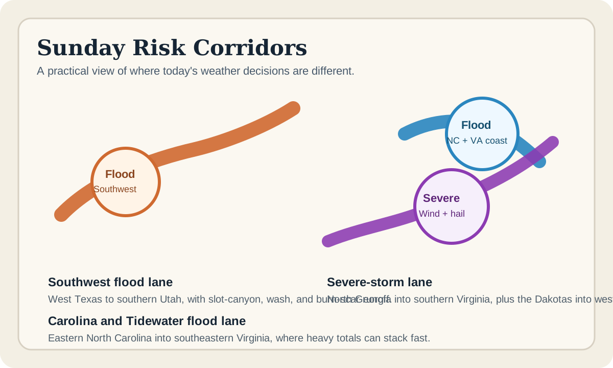
The answer depends on which lane you are in. In the Southwest, the main problem is fast runoff in places that can go from dry to dangerous quickly. In eastern North Carolina and southeastern Virginia, the issue is concentrated heavy rain in a humid corridor that can overwhelm roads and drainage. From north Georgia into southern Virginia, and again across the Dakotas into western Minnesota, the concern shifts toward damaging wind and hail, with flood issues still mixed in for some places.
Where the highest flood concern sits this morning
The Weather Prediction Center's Day 1 excessive-rainfall outlook, updated at 0811 UTC Sunday, keeps a Slight Risk across two very different zones: a broad Southwest corridor from West Texas to southern Utah, and a second zone over eastern North Carolina and the Virginia Tidewater.
For the Southwest, WPC says the monsoon setup remains favorable for another day of widespread convective activity. Slow storm motions and likely cell mergers raise the flash-flood threat, especially in slot canyons, dry washes, burn scars, and low desert areas. WPC's discussion says guidance supports the greatest 1 to 2 inch signal in the Slight Risk area and also points to localized 3 inch plus totals from portions of West Texas along the Mogollon Rim into southeastern Arizona.
For coastal North Carolina and southeastern Virginia, WPC says convection will form ahead of a slow-moving cold front in a very moist and unstable environment. Its discussion says heavy totals appear likely, with both the HREF and REFS showing high neighborhood probabilities for amounts above 3 inches inside the Slight Risk zone.
Why the Southwest flood risk is different from a normal thunderstorm day
Not every flood story looks like an interstate underpass filling up in a city. In the Southwest, the problem is often terrain.
WPC specifically flags slot canyons, dry washes, burn scars, and low desert areas. That matters because a road can look mostly clear until upstream rain sends runoff into a crossing, a canyon narrows the water flow, or a burned hillside sheds water faster than normal. A casual stop for hiking, sightseeing, or back-road driving can become the wrong plan even when the sky overhead does not look like the worst part of the storm.
If your day involves remote roads, washes, desert trailheads, or burn-scar terrain, this is the kind of forecast that deserves a stricter no-go rule than usual.
Why coastal North Carolina and southeastern Virginia need a different plan
The East Coast flood lane is less about terrain and more about rainfall efficiency. WPC points to a very moist air mass, strong instability, and enough large-scale lift to support heavy totals. In plain terms, storms in that corridor do not need to be especially dramatic to dump a lot of water in a short stretch of time.
That shifts the useful reader focus toward low-lying roads, poor-drainage spots, repeat errands, church or beach traffic, and the timing of any late-day drive. The main question is whether a place that usually drains well can still fail after one heavy burst or a second storm on the same route.
Where the severe-wind and hail threat is stronger
The Storm Prediction Center's 1300 UTC Day 1 outlook keeps a Slight Risk of severe thunderstorms from north Georgia into southern Virginia and across the Dakotas into western Minnesota.
SPC says the Southeast risk is mainly about scattered damaging wind gusts this afternoon, especially where eastward-moving storm clusters develop from Virginia into the northern half of North Carolina. It also says a couple of bands from Georgia into Alabama could produce wind damage, with isolated severe gusts possible into parts of Florida and southern Georgia.
Across the Dakotas and western Minnesota, SPC says storms should develop by mid to late afternoon as instability builds east of a lee trough. Its discussion says initial supercells may produce very large hail from 1 to 3.5 inches in diameter, followed by possible upscale growth into a severe-wind-producing line with peak gusts in the 60 to 85 mph range.
What drivers and households should do before the afternoon
- Check your local NWS office or hazards page before lunch, not after a warning starts scrolling.
- If your route uses flood-prone roads, desert washes, or low coastal drainage points, decide the alternate route now.
- Move vehicles away from weak limbs and skip exposed parking if your area is in the wind or hail lane.
- Charge phones, backup batteries, and any essential medical devices early.
- Do not treat a flooded road, wash crossing, or barricaded street as a judgment call you can make in the moment.
The best same-day weather move is usually a boring one. Leave earlier. Delay the errand. Skip the remote route. Park somewhere smarter. Boring is good when the alternatives are flood water and shattered glass.
What to remember if the power goes out
Severe-weather days often become outage nights. Ready.gov says people should turn off or disconnect appliances and electronics to avoid damage from return-power surges. It also says refrigerator doors should stay closed as much as possible, since a refrigerator usually keeps food cold for about four hours and a full freezer for about 48 hours.
Ready.gov also says generators and fuel should always be used outdoors and at least 20 feet away from windows, doors, and attached garages. If you need a longer outage checklist, Tadpost's power-outage heat-wave guide and blackout kit checklist cover the next-hour basics in more detail.
Flooded-road rules are still the most useful rule
National Weather Service flood-safety guidance is blunt for good reason: never drive around barriers blocking a flooded road. The same page says flood water can knock over an adult at six inches, carry away most cars at 12 inches of rushing water, and move SUVs and trucks in two feet of rushing water.
That is why today's most important weather call may have nothing to do with radar interpretation. It may simply be refusing the temptation to test whether your usual road is still good enough.
What to recheck later today
- the latest local NWS warnings and timing updates
- the current SPC Day 1 outlook if hail or severe wind is your bigger issue
- the WPC excessive-rainfall outlook if flash flooding is the main concern in your area
- any state DOT or local road-closure information if your route includes flood-prone crossings
- your local utility outage map if storms are already producing wind damage nearby
If you only do one thing, make it this: decide the backup route, backup indoor plan, and no-go thresholds before the sky makes the decision for you.
FAQ
Which areas have the broadest flash-flood concern on July 19?
WPC's 0811 UTC Day 1 outlook keeps Slight Risk flood corridors across the Southwest from West Texas to southern Utah, and across eastern North Carolina into the Virginia Tidewater.
Which areas have the stronger severe-weather signal?
SPC's 1300 UTC Day 1 outlook keeps Slight Risk severe corridors from north Georgia into southern Virginia and across the Dakotas into western Minnesota.
Why is the Southwest flood risk especially tricky?
Because runoff can accelerate through slot canyons, dry washes, and burn scars even when the danger is not obvious from one quick look at the sky where you are standing.
What is the best rule for a water-covered road?
Treat it as a no-go. NWS flood-safety guidance says never drive around barriers blocking a flooded road.
What should I do first if a storm cuts the power?
Unplug sensitive electronics, keep refrigerator and freezer doors closed, and keep any generator outdoors and at least 20 feet from doors, windows, and attached garages.
Sources
- WPC Day 1 Excessive Rainfall Outlook, updated 0811 UTC July 19, 2026.
- SPC Day 1 Convective Outlook, updated 1300 UTC July 19, 2026.
- National Weather Service flood-safety guidance, checked July 19, 2026.
- Ready.gov power-outage guidance, checked July 19, 2026.
The bottom line
Sunday's weather story is not one neat national headline. It is several practical local problems happening at once. In the Southwest, the smartest move may be avoiding washes, canyons, and burn-scar terrain entirely. In eastern North Carolina and southeastern Virginia, it may be treating a heavy-rain commute like a real hazard instead of a normal inconvenience. In the Southeast and Upper Midwest, it may be moving the car, watching the timing, and being ready for an outage before evening.